Main Menu
- News
- Press Releases
- Announcements
- Dates and Deadlines
- Planetary Surface Feature News
- Submission of News Proposals
- Newsletters
- Image Archive
- Video Archive
- Science
- Scientific Bodies
- Divisions
- Division A Structure
- Division B Structure
- Division C Structure
- Division D Structure
- Division E Structure
- Division F Structure
- Division G Structure
- Division H Structure
- Division J Structure
- Past Division Steering Committees
- Commissions
- Working Groups
- Centres
- Divisions
- Scientific Meetings
- Rules & Guidelines
- General Assemblies
- Future IAU Meetings
- Past IAU Meetings
- Symposia
- Joint Discussions (GA)
- Special Sessions (GA)
- Focus Meetings
- Regional Meetings
- General Assemblies
- GA Newspapers
- Post Meeting Reports
- ISYA
- CAP Conferences
- Meeting Proposals
- GA Symposia Letters of Intent
- Focus Meeting Letters of Intent
- Non-GA Symposia Letters of Intent
- GA Symposia Proposal Submissions
- Non-GA Symposia Proposal Submissions
- Focus Meeting Proposal Submissions
- Other Meetings
- Templates
- IAU Co-sponsored Meetings
- Scientific Collaborative Programmes
- Grants & Prizes
- IAU Grants
- IAU & The Gruber Foundation
- IAU, NASL and the KAVLI Prize
- TGF Cosmology Prize
- PhD Prize
- Scientific Bodies
- Publications
- IAU Publications
- Symposia
- Colloquia
- Highlights
- Transactions A
- Transactions B
- Focus Meetings
- Information Bulletins
- Regional Meetings
- Related Publications
- GA Newspapers
- Technical Meetings
- E-Newsletters
- WG Reports
- Commission Reports
- Division Reports
- Rules, Guidelines and Instructions for Proceedings
- Publishers
- IAU Publications
- Administration
- Members Administration
- Administrative Dates & Deadlines
- Resolutions
- IAU Executive Bodies
- Executive Committee
- Special Nominating Committee
- Membership Committee
- Finance Committee
- Resolutions Committee
- Past Committees
- Executive Committee
- Special Nominating Committee
- Membership Committee
- Finance Committee
- Resolutions Committee
- Editorial Boards
- Past Program Groups
- IAU Secretariat
- Statutes & Rules
- International Organisations Relations
- About the IAU
- Education
- IAU for the Public
- FAQ
- Themes
- Astronomy in Everyday Life
- How to Report a Discovery
- Careers in Astronomy
- Defining our Place in Cosmos
- The Constellations
- Light Pollution
- Measuring the Universe
- Near Earth Objects
- How to Participate in Astronomy Research
- Naming of Astronomical Objects
- Naming of Exoplanets
- Buying Star Names
- Naming Stars
- Pluto and the Solar System
- IAU Member Statistics
- Our Moon: the Moon
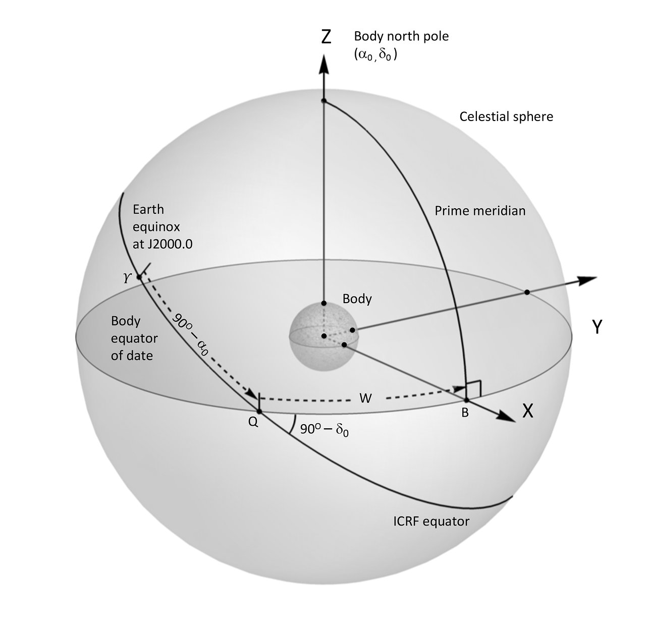
- Meteors & Meteorites: The IAU Definitions of Meteor Terms
- National Outreach Contacts
- Directory for World Astronomy
- Outreach Publications
- UNESCO-IAU Portal to the Heritage of Astronomy
- The International Year of Astronomy 2009
- Resources
- Press Room
- Social Media
- International Year of Light
- Astronomy for Development
- Overview
- OAD Grants
- Regional Nodes
- Andean Region
- Arab World and Arabic Language
- East Africa
- East Asia and Chinese Language
- Portuguese Language
- South East Asia
- South West and Central Asia
- Southern Africa
- West Africa
- Opportunity: New Regions